|
Seven volcanoes are situated underneath the Vatnajokull ice-cap and most
of them are active volcanoes. Grimsvotn volcano is together with Hekla, Iceland's most active volcano since the Middle Ages.
Grimsvotn last erupted in 1996, in 1998 and yet again in 2004. Kverkfjoll is a large glaciated central vulcano on the northern
edge of Vatnajokull, with a powerful highteo-nature ared where there are mudholes. Steam bowholes and a luke-warm lake. Undereneath
the glacier is an ice cavern system several km long.

Vatnajokull is named after sub-glacial lakes in a very volcanically active
region in its centre. The sub glacial landscape is an undulating plateau (600-1000m) with valleys and gorges. The icecap rises
between 1400 and 1800 m above sea level. The ablation elevation is a bit different, 1100 m in the south, 1200 m in the west
and 1300 m in the north. A great number of glacier snouts of different sizes flows down onto the lower lying areas. No glacier
in Iceland has been researched more thoroughly than Vatnajokull. The research started in 1934, when the lake region erupted
and ever since the Iceland Glaciological Society was founded in 1950 it has been continued every year. The Iceland Glaciological
Society owns huts in several places on the icecap. The latest eruptions of the lake region took place in 1996, in 1998 and
again in 2003. The first confirmed trip across the icecap from the south and back was accomplished in 1875 by an Englishman
and a few Icelanders. They were the first to see the Askja eruption the same year and report it to the people living on Lake
Myvatn.
Volcanic fissure systems of the Mid-Atlantic Ridge plate boundary are partly
covered by the western part of the Vatnajokull ice cap. Two major volcanic centers lie beneath the ice, the Bardarbunga volcanic
centre and the Grimsvotn volcanic centre, both with large subglacial caldera depressions. The Bardarbunga centre is a part
of a fissure system extending over 100 km to the south and some 50 km to the north of the glacier. The last eruption within
the Bardarbunga centre occurred in 1910, but eruptions on the fissure system have occurred in 871 AD, 1477 AD and 1862 AD,
all producing substantial amounts of lava.
Late in the evening of September 30, 1996, seismometers detected the beginning
of an eruption under the glacier. One of the volcanoes had previously collapsed and formed a caldera named Grimsvotn, in which
a subglacial lake had been accumulated. Late on the first of October, the day after the eruption started, the surface of the
ice over the caldera had risen ten to fifteen meters. The next day, the eruption broke through the surface of the ice, emitting
an ash cloud ten kilometers high. The volcano quieted on the thirteenth, but the ice continued to melt and overflow the Grimsvotn
lake. More than three cubic kilometers of ice melted, but little was emitted through normal runoff points. Since an ice dam
and the caldera itself held the melt back, the jokulhlaup would not occur until November, or at least one month later.
At 7:20am on the fifth of November, the meltwater burst vertically from
two kilometers above the tongue of the glacier. By four that afternoon, the jokulhlaup was fully realized. A mixture of sediment,
meltwater, and ice moved at ten kilometers per hour from the full twenty-kilometer width of the glacier's terminus across
Skeidararsandur, forming standing waves three and four meters high. The total flow peaked at over fifty thousand cubic meters
per second in the five outwash channels, making it briefly the second largest river of the world. The flood obliterated a
376-meter-long bridge, the majority of a second bridge nine hundred meters in length, twelve kilometers of roadway, twenty-three
power-line towers, and causing fourteen million United States dollars in damage while adding seven square kilometers to the
area of Iceland. Thankfully, there were no fatalities or injuries, and the flood did not reach any nearby settlements.
There is little doubt that the events occuring on the eastern part of Iceland
in late 1996 had an impact felt around the world. The phenomenon of a sub-glacial volcanic eruption is not often encountered;
therefore, numerous journalists and scientists from around the world met in Iceland during the eruption to study the events
and ramifications of these occurances. The study of volcanoes, especially active ones, located under glaciers, or "glacivulcanology",
if not already an area of study, should become one in the future, in order to unlock more of the secrets of our planet. Undoubtedly,
anything learned from the Vatnajokull incident and others like it can be applied to other fields, including plate tectonics,
the behavior of the land on other planets, and run-of-the-mill vulcanology. For myself and other exchange students in Iceland
at this time, these events added another facet to our own appreciation for this little Atlantic island, one that captured
the attention of the world for a few months.
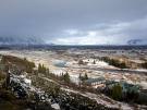
The largest glacier in Iceland is Vatnajokull and it is the largest glacier
mass in Europe. It covers an area of roughly 8100 km 2, and is about 1000m thick where it is thickest. Its average thickness
is between 400 and 500m, and the total ice volume of Vatnajokull is probably in the vicinity of 3300 cubic km. The ELA lies
at ca. 1100 m a.s.l. along its southern margins, at 1200 m along its western part, and at 1300 m in its northern part. About
60% of the glacier surface is above the ELA. The ice cap covers a highland plateau, generally reaching 600-800 m altitude,
but dissected by numerous broad and narrow subglacial valleys. A number of large volcanoes are covered by the great ice cap,
including Oraefajokull (Öræfajökull) (2111 m), Bardarbunga (Bárðarbunga) (2020 m) and Grimsvotn.
Seven volcanoes are situated underneath the Vatnajokull ice-cap and most
of them are active volcanoes. Grimsvotn volcano is together with Hekla, Iceland's most active volcano since the Middle Ages.
Grimsvotn last erupted in 1996, in 1998 and yet again in 2004. Kverkfjoll is a large glaciated central vulcano on the northern
edge of Vatnajokull, with a powerful highteo-nature ared where there are mudholes. Steam bowholes and a luke-warm lake. Undereneath
the glacier is an ice cavern system several km long.

Iceland´s highest peak, Hvannadalshnjukur is in Vatnajokull Glacier and
rises 2110 meters above Iceland´s south shore.
|
 |
|
Eyjafjallajokull is cone shaped, the 6th biggest
glacier in Iceland. It is situated to the north of Skógar and to the west of the bigger glacier Myrdalsjokull.
The ice-cap of the glacier covers an active volcano (1666m in height) which
has erupted rather frequently since the ice-age. The last eruption was in 1821-23, causing a fatal glacier run. The crater
of the volcano has a diameter of 3-4 km, the glacier covering an extension of about 100 km².
Svereal steep glacier tongues protrude from the mountain. Two of them Gigjokull
and Steinholtsjokull drop into two small proglacial lakes filled with floating calved Icebergs. The lake
in front of Gigjokull is called Jokullon. The lake in front of Steinholtsjokull is smaller. River Steinholtsá
flows out it into Krossá. These lakes are formed by encircling walls built up by tons of terminal moraine.
In 1967 there was an enormous landslide onto Steinholtsjokull.
On january 15 th 1967 at 13.47.55 there was an explosion in the cliff Innstihaus. It can be timed because the earthquake meters
in Kirkjubæjarklaustur picked up the turbulance. When the landslide of about 15 million cubic meters hit
the glacier a huge wave of air, ice, water and huge cliffs started to run from under the clacier and into the lagoon at the
foot of the glacier. The wave got as high as 75 m from the floor of the valley. The cliffs stopped soon afterward
but water and ice touched the floor of the old brigde over Markarfljót one and a half hour later.
Under the hills of Eyjafjallajokull stands the mountainridge Eyjafjoll
but they were once part of the Atlantic coastline. The sea now being in a distance of about 5 km from there, the
former coastline left behind sheer cliffs with a multitude of beautiful waterfalls, the best known of them being Skógafoss. In case of stark winds, the water of minor falls is even sometimes blown up the mountain.

The area under Eyjafjöll where numerous farms stand now
along the black sand coastal strip was in the past under water but clacial deposits gradually pushed the
coastline into the sea.
|
|
|
|
|
|
|
|